Côte d’Azur mountain bike ride through the Esterel coastal mountains from Auribeau-sur-Siagne
Route Overview
Scenic mountain bike ride round the Peygros mountain on good trails with alternating vistas over the mediterranean sea and the foothills of the alps. This cycle route is suitable for all abilities, but the alternative singletrack route will delight more enthusiastic riders.
The mountain bike ride starts just 20 km inland from Cannes on the Cote d’Azur and takes you through some of the classic Mediterranean vegetation and rocky terrain you associate with the south of France and the coastal Esterel Mountains.
In January and February the mountains are in full bloom with the bright yellow flowers of the mimosas bush.
This relatively short circuit, well suited to a family outing, takes place exclusively on small roads and off road trails. Don’t miss the side trip to the viewpoint to take in the wonderful panorama.

The Route
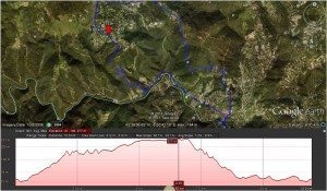
Park near the edge of Auribeau-sur-Siagne (90 m) and cycle back down the RD 509 towards Pégomas until you reach the Cante-Perdrix junction (49 m).
Turn right and look out for the signposted “piste DFCI de Peygros”, turn left onto the steep narrow Chemin des Vayoux.
The road heads up hill and will soon become more of a track, continue until you reach a gate preventing access to motor vehicles.
Cross the barrier and take the left hand trail signposted towards “Peymeinade” (part of the GR51) and climb, heading west, until you reach another gate.
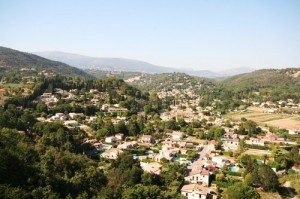
Go through the gate and soon after reaching the Peygros saddle (205 m), head left down the small paved road that winds up through some pretty villas and takes in a magnificent view over the villages of Cabris and Tignet.

This leads you out onto Avenue de Peygros. Head west, through one crossroads and at the second, turn left onto the Saouves trail that cuts across the hillside. Then take the Apier trail that runs down the hill through the shrubbery. Leave the trail by taking the left track towards Candéou. Soon afterwards, the the APIE drinking water factory will come in to view.
Turn left onto the small paved road that winds along the left bank of the Siagne to join the Gabre trail and the junction with the RD 509, which brings you back to Auribeau.
[box type=”info” size=”medium” style=”rounded” border=”full” icon=”https://www.ultimatefrance.com/wp-content/images/icons/gps-icon-xsmall.gif”] GPS Download (GPX File) Google Earth Download (KML File)[/su_box]
Singletrack Alternative
Once you reach the GR51, round the first corner and take the singletrack trail up to the summit of Peygros (301 m). On your way back down from the summit take the first trail on your left, this will lead you back to the Peygros saddle and the main trail.
Once at the saddle, take the trail marked with a yellow sign towards the south west. There’s a bit of a climb before you drop through a succession of switchbacks to the Siagne river. This effectively cuts the ride in half, so why not loop back round and do it again!

Route Notes
- Departure point: Auribeau-sur-Siagne
- Altitude at trail start: 90 m
- Length: 9 km
- Climb: 300 m
- Descent: 300 m
- Duration: 1:30 hours
- Difficulty: easy
- Best time to ride: year round
Getting There
From Cannes, follow the motorway A8 west to Mandelieu. At the motorway exit, turn right on to RD.109 Pégomas. Turn left onto the RD 9 towards Grasse and take the left turn sign posted Auribeau-sur-Siagne, the starting point of the ride.
[mappress mapid=”12″]
